How to interpret wave and wind forecast for surfing

Rating: 4.3. From 6 votes.
Please wait...

We now have good wave forecast services, which allow us to plan our surf sessions in an optimal way, you just need to know how to read and interpret those swell and wind forecast. In this article we will explain how to analyze and interpret surfing forecasts.

1. Understanding the formation of the waves

It is essential to you understand how waves are formed. Waves are generated by strong winds that form a ripple on the surface of the sea. This wave propagates, travels thousands of kilometers, before reaching the coast to break, and form the waves that we can surf.

Winds are due to a pressure difference between two air masses: a depression, which is a mass of air with low pressures, and an anticyclone, a high pressures zone. To regulate and try to balance the difference of pressures, the wind is formed. The higher the difference is between the pressures of the anticyclone and the depression, the stronger the wind will blow, he larger the swell is. The longer the wind blows, the more consistent the swell will be.

The further away from our coast this phenomenon occurs, the more orderly and more spaced the waves will come, we say that the swell period is longer. The period represents the time between two undulations, and is directly associated with the power of the waves.

Some forecast pages such as magicseaweed or surf-forecast show those maps, even with animations, and allow you to get a first idea of ​​what´s happening.

2. The height of the waves

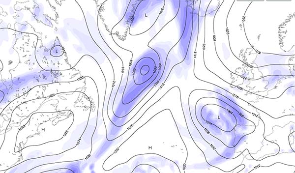
As we have said before, the stronger the wind has blown, the bigger the swell will be. The swell will turn into waves when it hits the coast. Depending on the orientation of the beach where we are going to surf, we can have waves of the same size or larger than the swell, if the beach is facing the swell, and if the bottom of the ocean is favorable.  Or smaller if the beach where we surf is sheltered.

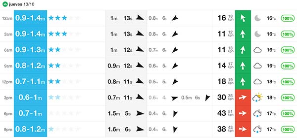
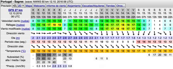
Some forecast pages, such as windguru, only indicate the height of the swell. You will have to deduce the height of the waves, depending on your beach. Look at the direction of the swell, look at the orientation of your beach. If the swell comes directly, you have good chances that the waves will be the same height as the swell. If we have for example a North West swell, and your beach is faced to the south west, waves will probably be smaller than the swell.

Other pages, such as magicseaweed, give the height of the swell and the height of the waves. Depending on the orientation of the swell and the beach, and probably taking into account the particularities of the beach, they dare to give a minimum and maximum height of the waves. It is very well in theory, but do not forget that wave heights are the result of a mathematical formula, which sometimes gives incoherent results. The most reliable thing is to look at the height of the swell, and make yourself an idea of ​​the size of the waves based on your knowledge of the beach.

3. The swell period

A storm that generates strong winds for a long time and far from our coasts will generate a swell with a longer period. The longer the period is, the more powerful the waves will be, the more spaced they will break, we will have a cleaner surf, with more orderly and more powerful waves.

Some pages, such as surf-forecast, announce the energy of the wave. They calculate this data with a formula based on the height and the period of the swell. But to make it simple, just remember that the higher the period is the more power and the more orderly the waves will be.

That is why the waves in the Mediterranean Sea have less power than in the Basque country. The wind generated by the swell blows very close to the coast. You can clearly see how the waves get very close to one another, and push less. On the opposite, the swell that reaches the Basque Country  is caused by a wind that has blown in the Atlantic, far away from the coast, the swell reaches the coast having traveled much more kilometers than in the Mediterranean.

4. The orientation of the swell

The orientation is also a parameter to look at, although it usually does not vary much. But small variations of orientation can sometimes have great effects on the waves.

5. The wind

Be careful, we talked here about the wind blowing locally on the beach, not the wind that caused the waves. We try to have as little wind as possible. But also look at the direction of the wind. If the wind blows offshore, that is, in the opposite direction of the waves, it will not affect and may even improve the quality of the waves. On the opposite, if it blows onshore, in the same direction as the waves, it will crush them and make them worse.

Some pages, such as magicseeweed or wisuki, attribute a color code to the wind to illustrate whether the wind will be annoying or not. But knowing the orientation of your beach and the direction of the wind, you can draw the same conclusion.

6. Real-time data

When the day comes, nothing better than to compare the forecast with real data.

Some pages, indicate the height of the swell measured by buoys located on the high seas.

Other pages like spotfav have webcam located on the beaches, which allow you to see the waves breaking in real time.

All this information that we can find on the internet, sometimes free, sometimes through a monthly payment, and gives us valuable information, especially if we are not lucky enough to live close to the coast. They allow us to anticipate, plan, and minimize the risk of moving for nothing.

Hopefully this article will allow you to better understand how the waves are formed, what are the key data, and so be able to make your self-criticism of the forecasts, compare the information of the different websites and make your own forecast!

Reference web pages for surf forecasting:

www.windguru.com

www.magicseaweed.com

es.surf-forecast.com

www.puertos.es

www.spotfav.com

Products recommended for you:

><

Summary
Rating: 4.3. From 6 votes.
Please wait...

Leave a Reply

Your email address will not be published. Required fields are marked *